Line Graph
Chart overview
Line graphs are fundamental visualizations for displaying continuous data and trends over time.
Key points
- By connecting data points with lines, they effectively communicate the direction and rate of change in your data.
- Multiple lines can be used to compare trends across different categories, making line graphs ideal for stock prices, temperature changes, sales trends, and any time-series analysis.
- The connecting segment carries an implicit claim - that the quantity varies continuously between the plotted points - so lines are right for time series and ordered continuous x-values and wrong for unordered categories (connecting category A to B to C implies a progression that doesn't exist; use bars there).
Practical guidance
A few choices govern honesty and readability. The y-axis baseline is a judgment call, not a rule: zero is safest for magnitudes, but for data that never approaches zero (body temperature, stock prices) a zero baseline flattens the very changes you're plotting - so crop deliberately and make the scale obvious rather than dramatize a tiny change on a stretched axis. Beyond about five lines the plot becomes a spaghetti tangle; label lines directly at their right end instead of relying on a legend the eye must ping-pong to, gray out context series and color only the ones you're discussing, or break into small multiples. Distinguish series by more than hue (line style or direct labels) so colorblind readers and grayscale prints still work, and don't over-smooth - interpolating monthly points into silky curves invents values that were never measured. Mark genuine data points when they're sparse, and never connect across a real gap in the data (insert NaNs so the line breaks) rather than drawing a straight bridge over missing time.
Create a Line Graph with your data using AI — no coding required.
Python Tutorial
How to create a line graph in Python
Use the full tutorial for implementation details, troubleshooting, and chart variations in matplotlib, seaborn, and plotly.
How to Plot Time Series Data in PythonExample Visualization
Create This Chart Now
Generate publication-ready line graphs with AI in seconds. No coding required – just describe your data and let AI do the work.
View example prompt
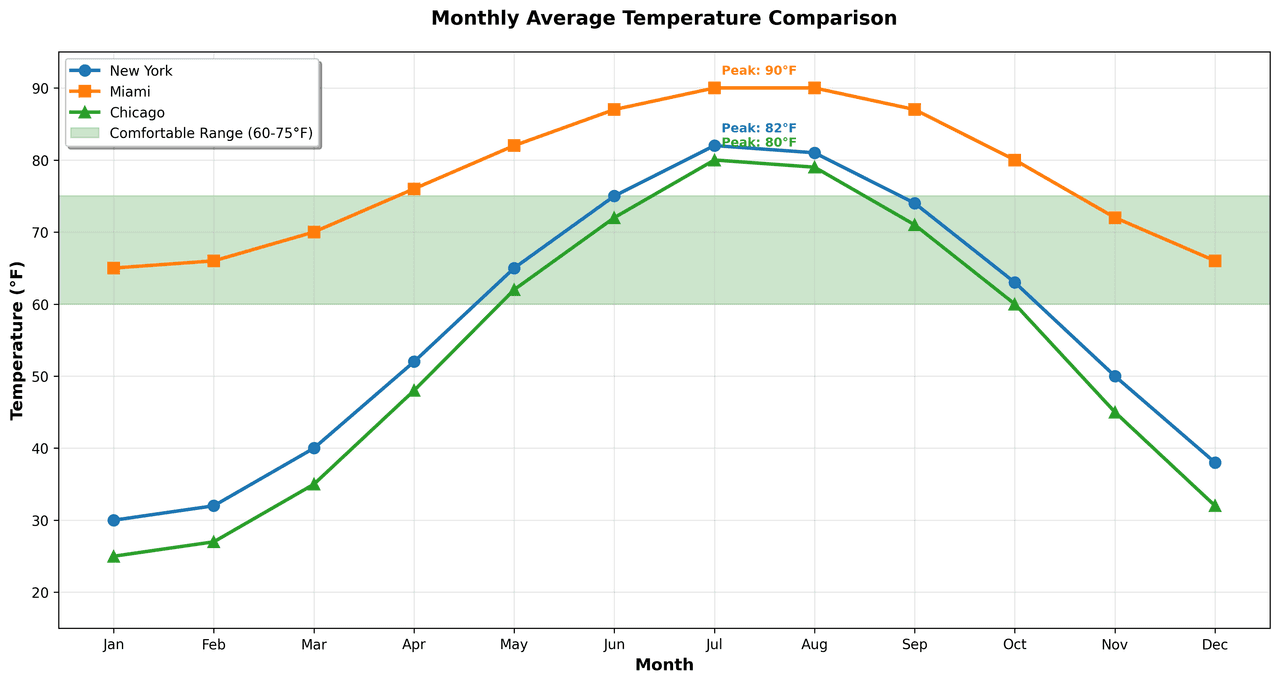
"Create a multi-line graph comparing 'Monthly Average Temperature' for 3 cities (New York, Miami, Chicago) over a full year (Jan-Dec). Generate realistic data: New York (30°F-85°F), Miami (65°F-90°F), Chicago (25°F-80°F) with appropriate seasonal patterns. Use distinct line colors (NYC: blue, Miami: orange, Chicago: green) and marker styles (circle, square, diamond). Add a shaded region showing the 'comfortable range' (60-75°F). Include grid lines, format Y-axis with °F, add month abbreviations on X-axis. Title the chart professionally, add a legend positioned outside the plot, and annotate the hottest and coldest points for each city."
How to create this chart in 30 seconds
Upload Data
Drag & drop your Excel or CSV file. Plotivy securely processes it in your browser.
AI Generation
Our AI analyzes your data and generates the Line Graph code automatically.
Customize & Export
Tweak the design with natural language, then export as high-res PNG, SVG or PDF.
Newsletter
Get one weekly tip for better line graphs
Join researchers receiving concise Python plotting techniques to improve chart clarity and reduce revision cycles.
Python Code Example
# === IMPORTS ===
import pandas as pd
import numpy as np
import matplotlib.pyplot as plt
from datetime import datetime

# === USER-EDITABLE PARAMETERS ===
x_col = 'Date'          # Change: column name for x-axis (datetime)
y_col = 'Temperature'   # Change: column name for y-axis (numeric)
group_col = 'City'      # Change: column name for grouping variable
figsize = (12, 6)       # Change: figure size in inches
title_fontsize = 18     # Change: title font size
label_fontsize = 16     # Change: axis label and tick font size
colors = ['#1f77b4', '#ff7f0e', '#2ca02c']  # Change: hex colors for each city
markers = ['o', 's', '^']  # Change: markers for each city
line_width = 2          # Change: line width
show_legend = True      # Change: whether to show legend

# === DATA PREPARATION ===
# Generate example dataset: monthly average temperatures for 3 cities over one year
np.random.seed(0)
months = pd.date_range(start='2023-01-01', periods=12, freq='MS')
cities = ['City A', 'City B', 'City C']
data = []

for city in cities:
    if city == 'City A':
        base = 20
        trend = 5
    elif city == 'City B':
        base = 15
        trend = 3
    else:  # City C
        base = 10
        trend = 1
    temps = base + trend * np.sin(np.linspace(0, 2*np.pi, 12)) + np.random.normal(0, 2, 12)
    for date, temp in zip(months, temps):
        data.append({'Date': date, 'City': city, 'Temperature': temp})

df = pd.DataFrame(data)

# === ANALYSIS ===
# Compute max temperature per city
max_temps = df.groupby(group_col)[y_col].max()
max_months = df.loc[df.groupby(group_col)[y_col].idxmax()][['Date', group_col, y_col]]
mean_temps = df.groupby(group_col)[y_col].mean()

# Print analysis results
print("Maximum temperatures per city:")
for city in cities:
    month_str = max_months.loc[max_months[group_col]==city, 'Date'].dt.strftime('%b %Y').values[0]
    print(f"  {city}: {max_temps[city]:.1f}°C on {month_str}")
print("\nMean temperatures per city:")
for city in cities:
    print(f"  {city}: {mean_temps[city]:.1f}°C")

# Determine city with highest max temperature for title
top_city = max_temps.idxmax()
top_temp = max_temps[top_city]
top_month = max_months.loc[max_months[group_col]==top_city, 'Date'].dt.strftime('%b').values[0]

# === PLOT CREATION ===
fig, ax = plt.subplots(figsize=figsize)

# Plot each city's temperature trend
for i, city in enumerate(cities):
    city_data = df[df[group_col]==city].sort_values(x_col)
    ax.plot(city_data[x_col], city_data[y_col],
            label=city,
            color=colors[i],
            marker=markers[i],
            linewidth=line_width,
            markersize=6)

# Formatting
ax.set_title(f"{top_city} reaches highest temperatures of {top_temp:.1f}°C in {top_month}",
             fontsize=title_fontsize)
ax.set_xlabel('Month', fontsize=label_fontsize)
ax.set_ylabel('Temperature (°C)', fontsize=label_fontsize)
ax.tick_params(axis='both', which='major', labelsize=label_fontsize)

# Legend
if show_legend:
    ax.legend(loc='upper left', fontsize=label_fontsize)

# Annotation of max temperatures
max_temps_str = ', '.join([f"{city}: {max_temps[city]:.1f}°C" for city in cities])
ax.text(0.95, 0.85, f"Max temps: {max_temps_str}",
        transform=ax.transAxes,
        ha='right', va='top',
        bbox=dict(boxstyle='round', facecolor='white', alpha=0.8))

# Layout adjustments
plt.subplots_adjust(top=0.90, bottom=0.12, left=0.12, right=0.95)
plt.tight_layout()

# Display plot
plt.show()
# END-OF-CODEOpens the Analyze page with this code pre-loaded and ready to execute
Console Output
Annual Temperature Statistics:
New York: min=30°F, max=82°F, avg=54.6°F
Miami: min=65°F, max=90°F, avg=79.8°F
Chicago: min=25°F, max=80°F, avg=52.3°F

Comfortable Months (60-75°F): NYC=7, Miami=4, Chicago=5
Common Use Cases
- 1Stock price tracking over time
- 2Website traffic analysis
- 3Temperature and weather trends
- 4Sales performance comparison
Pro Tips
Use distinct colors and markers for multiple series
Consider adding a legend outside the plot area
Highlight important data points or events
Frequently asked questions
When should you use a line graph?
Line graphs are fundamental visualizations for displaying continuous data and trends over time. By connecting data points with lines, they effectively communicate the direction and rate of change in your data. Common applications include stock price tracking over time, website traffic analysis, and temperature and weather trends.
Which Python libraries can create a line graph?
A line graph can be built in Python with matplotlib, seaborn, and plotly — matplotlib for precise control over axes, annotations, and journal styling, seaborn for statistically-aware defaults on tidy data, and Plotly for interactive hover, zoom, and web sharing. In Plotivy you describe the figure and it writes the matplotlib code for you.
Can I make a line graph without writing Python code?
Yes. Describe the line graph you need in plain language and upload your dataset — Plotivy's AI writes the Python code and renders a publication-ready figure. You still get the full, editable matplotlib source, so nothing is locked in a black box.
What are best practices for a clear line graph?
Use distinct colors and markers for multiple series. Consider adding a legend outside the plot area.
Long-tail keyword opportunities
High-intent chart variations
Library comparison for this chart
matplotlib
Best when you need full control over axis formatting, annotation placement, and journal-specific styling for line-graph.
seaborn
Fastest path to statistically-aware defaults and tidy-data workflows, especially for grouped and distribution-focused line-graph views.
plotly
Best for interactive hover, zoom, and web sharing when collaborators need to inspect values directly from line-graph figures.
Scientific Chart Selection Cheat Sheet
Not sure whether to use a Violin Plot, Box Plot, or Ridge Plot? Download our single-page reference mapping the most-used scientific chart types, exactly when to use them, and the core Matplotlib/Seaborn functions.